 Mobile GIS ArchitectureAdmin
Mobile GIS Architecture

Architecture of Mobile GIS Introduction The mobile GIS is a new paradigm in Geography and it has the power not only to deliver the geospatial data to the mobile user everywhere and anytime, but also it personalizes the geographical data and enables the capture of the geographical dimension of the personal information and the ease interaction with geographic content.
The geoinformatics reached a matured comprehensive level as it appears in different aspects such as digital mapping, GPS and remote sensing. The mobile GIS emerges at the intersection of the evolution of mobility with development of geoinformatics, in the same time it depends on the exponential advancement in hardware mainly wireless networking and computing, and it represents the user demand and ambition to exploit the geographic knowledge in decision support everywhere anytime. Telegeomatics, Telecartography, and Location Based Services (LBS) were used to refer to the science and art of manipulating geographical information on mobile device.
The Smartphone comes at the stage of incorporation between the notebook (laptop or portable computer) and the mobile phone. The mobile device inherited all the functionalities from laptops and personal computers, in addition to the mobility and GSM communications from mobile phone, however it suffers only from the small screen size which acts as a confront to geovisualization. The mobile GIS is in the core of the ICT revolution. The mobile users are moving in a geographic space and they know their positions and they have access to the wide available geographical data and information. It is essential requirement to exploit these tools online for spatial decision support and for movement management and operations. The main objective of the mobile GIS is to minimize the time and energy of navigation and movement and make them more efficient. Several reasons motivated the mobility computing in general and mobile GIS in particular.
First, the expansion of wireless communication, second the mobile networks are everywhere worldwide, third the exponential advancement in hardware, and finally the availability of geographical databases. The revolution of the PC and internet was dissolved in the mobility revolution that replaced it. The figures and statistics about the mobile phone and ICT from ITU in next table provide a clear vision about the mobility. Worldwide Indicator 2010 2013 mobile cellular subscriptions 5.3 billion 6.8 billion mobile cellular subscription 77.2 per 100 inhabitants 96.2 per 100 inhabitants telephone land lines 16.5 per 100 inhabitants 17.8 per 100 inhabitants From the above information, over 85% from world population possess a mobile phone. The global smartphone shipments reached 1 billion units during 2013, accounting for growing of 40% with decline in price of 12% (thenextweb.com). GIS, Mobile GIS, LBS and Web GIS Although in some literature they may refer to the same system, two differences exist between mobile GIS and Web-GIS. The Web-GIS does not have any GIS software neither application at the client side, and needs to be connected to the internet for functionality.
The mobile GIS requires GIS applications and software to be installed on the mobile device, and from communications aspect, the mobile GIS can be online (connected mode) or offline (standalone mode). The LBS was established to pay back the cost of the legalization of e-911 in USA and e-112 in EU. The design of LBS was a business process rather than scientific or engineering process. The LBS is based on the determination of the location of the mobile device based on the cell ID of the mobile network then receives from the user his/her inquiries then returns the answer via SMS or WAP service.
Characteristics of LBS:
1) Position is relative to the cell ID of mobile network
2) The service has a cost paid by user upon request
3) It is a non-voice service based on text
4) No maps are provided
5) The user does not perform any GIS operations The mobile GIS was developed as an extension to classical GIS systems and is a part from it. Architecture of Mobile GIS The mobile GIS is a typical information system ported by a single user everywhere and anytime. The mobile GIS hosts applications related to geography and it is essential for the access of the geodatabases locally or remotely. The architecture of mobile GIS is presented which include the hardware, operating system, GIS software, and geospatial data. The communications capabilities and outdoor positioning techniques are analyzed in details. Components of Mobile GIS System
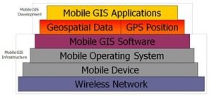
The mobile GIS system is a micro-level cloning of GIS systems. It has the main components of classical GIS systems with obvious differences. The main components of desktop GIS are hardware, software, data, applications, and users. The mobile GIS has the same GIS components, mobile device as hardware, light GIS software, limited data, and special applications. Figure 1 General architecture of mobile GIS system The general architecture of mobile GIS as shown in above Fig. is composed of the hardware of mobile device with its operating system connected to a wireless network. The mobile device has mobile GIS software installed in the hard disk with the required geospatial data. The positioning tool within the mobile device displays the position of the mobile device on the geospatial data. The GIS applications are performed based on the geospatial data, position value and mobile GIS applications. Also, the figure defines the infrastructure of mobile GIS which the user acquires before moving and it is composed of the wireless network, the mobile platform and the mobile GIS software. The development of mobile GIS is the upper part of the system and it is variable according to the place of interest and the application to the user. The mobile platform is the combination of the hardware architecture of the mobile device and its operating system, both of them are the base of the mobile GIS that is installed and used on this platform. The mobile device has specific and unique characteristics, first it belongs to a single and unique person, it is a user identifiable device and two persons do not share the same mobile device such as desktops and land line telephones.
Second, it is always-on wearable device. Third, the most used device all over the world, almost each adult holds one. Mobile phone is considered the seventh mass media It has several realizations such as smartphone, PDA, intelligent device, handheld navigator and others. The mobile device is a multi-objective equipment, with fundamental characteristics of small size and GSM connectivity, in addition to modern accessories such as digital camera, video recording, sound recording, GPS, A-GPS, Wi-Fi, Bluetooth, IrDA, FM receiver and transmitter, keypad (mobile phone or qwerty), processor, RAM, hard disk, and a small (touch) screen (2 – 10 inch). The mobile device is a cellular phone, executes computer programs, and connects to the internet and/or mobile/computer devices. The mobile device moves on earth, on water, on air, can be used indoor or outdoor. The significant hardware component to geoinformatics is the GPS receiver of the mobile device. It can be embedded inside the device or separated from it and connected via Bluetooth or direct cable. The capabilities of mobile device are augmented by adding GPS chip to it, so that it knows its absolute position. These two features, wireless connectivity to internet, and location awareness, in addition to the advancement in hardware capabilities, smooth the road to mobile GIS, as evolution of web GIS and traditional (Desktop) GIS. User of Mobile GIS The internet, geodatabases, and mobile devices changed dramatically the type of the user of GIS. Not anymore the use of GIS is restricted to experts and specialists, now the normal user who can communicates via mobile phone needs to use the mobile GIS, and even more, they are currently the collectors for geospatial data.
Source : Directions Magazine


